Reviews
User Score
Rate This
Descriptions:
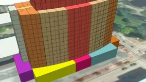
Join us as we explore the impact of Geographic Information Systems (GIS) on the AEC industry. In this session we explore the pivotal role of GIS in driving much-needed change, uncover the limitless possibilities when combined with IoT, AI, knowledge graphs, remote imagery, reality-capture, CAD, BIM and more.
Using a combination of real-world examples and research projects, learn how the convergence of GIS with the current wave of transformative technologies is reshaping the AEC landscape.
- Witness the power of AI and deep learning models leveraging GIS to unlock valuable insights.
- See examples of the potential of knowledge graphs, which seamlessly connect vast amounts of information in the AEC industry.
- Experience the game-changing capabilities of remote imagery and its integration with GIS, allowing for accurate site analysis, progress monitoring, and precise measurements.
- Discover how GIS, when combined with IoT, changes the way we collect and analyze spatial data in real time.
- Learn how BIM, when coupled with GIS, provides a data-rich foundation for designing, visualizing, and managing complex projects.
Through captivating and practical examples, you will gain insights into how GIS-driven solutions are transforming urban planning, infrastructure development, interiors planning, and sustainable design practices. Discover how the integration of these technologies enables professionals in the AEC industry to work smarter, faster, and more collaboratively